Topics
- Hyperspectral Image Restoration
- Hyperspectral Multi-sensor Data Fusion
- Spatial Information Modelling
- Image classification in hyperspectral images
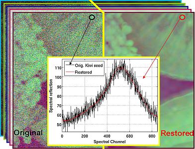
Hyperspectral Image Restoration
Despite advances in sensor technology, hyperspectral (HS) images are inevitably degraded by noise and blur, which can affect information retrieval and content interpretation. Using denoising and deblurring as a preprocessing tool will improve various post-processing tasks, e.g. classification, target detection, unmixing, etc.
We propose a novel restoration algorithm for HS images. Our method first uses PCA to decorrelate the HS images and separate the information content from the noise. The first k PCA channels contain most information of the HS image, and the remaining B ? k PCA channels (where B is the number of spectral bands of HS image) mainly contain noise. If deblurring is performed on these noisy and high-dimensional B ? k PCs, then it will amplify the noise of the data cube and cause high computational cost in processing the data, which is undesirable. Therefore, we only restored the first k PCA channels. We remove the noise (without restoration) in the remaining PCA channels using a soft-thresholding scheme.
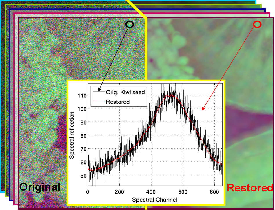
Figure 1: Hyperspectral image restoration
Contact: prof.dr.ir. Hiep Luong
References:
W. Liao, X. Huang, F. Coillie, S. Gautama, A. Pizurica, W. Philips, H. Liu, T. Zhu, M. Shimoni, G. Moser, and D. Tuia, “Processing of Multiresolution Thermal Hyperspectral and Digital Color Data: Outcome of the 2014 IEEE GRSS Data Fusion Contest,” IEEE Journal of Selected Topics in Applied Earth Observations and Remote Sensing, vol. 8, no. 6, pp. 2984-2996, June 2015.
W. Liao, B. Goossens, J. Aelterman, H. Luong, A. Pizurica, N. Wouters, W. Saeys, W. Philips, "Hyperspectral image deblurring with PCA and total variation", In 5th workshop on hyperspectral image and signal processing: evolution in remote sensing (WHISPERS 2013), Florida, US, pp. 1-4, 2013.
L. Loncan, L. B. Almeida, J. Bioucas Dias, X. Briottet, J. Chanussot, N. Dobigeon, S. Fabre, W. Liao, G. A. Licciardi, M. Simoes, J. Y. Tourneret, M. A. Veganzones, G. Vivone, Q. Wei, and N. Yokoya, "Hyperspectral pansharpening: a review," IEEE Geoscience and Remote Sensing Magazine, vol. 3, no. 3, pp. 27-46, September 2015.
Hyperspectral Multi-sensor Data Fusion
Nowadays, advanced technology in remote sensing allows us to get multi-sensor and multi-resolution data from the same region. However, fusion of these data sources for classification remains challenging problems.
We proposed a graph-based fusion method to couple dimensionality reduction and data fusion of multi-sensor remote sensing data. Our approach by fusing hyperspectral and LiDAR data for classification won the "Best Paper Challenge" Award of the 2013 IEEE GRSS Data Fusion Contest.
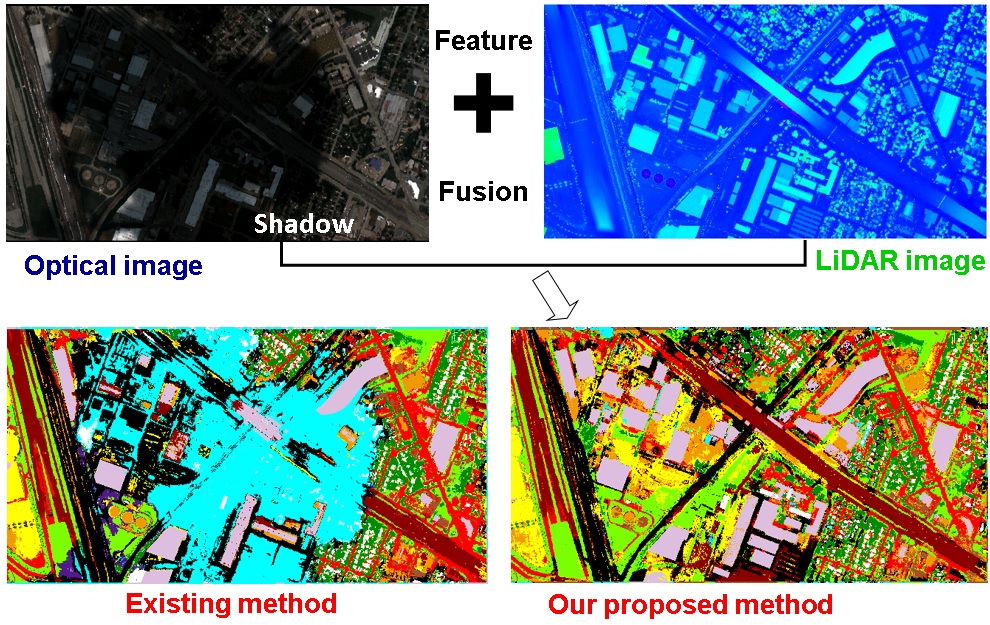
Figure 1: Hyperspectral image fusion
Contact: prof.dr.ir. Hiep Luong
References: - W. Liao, R. Bellens, A. Pizurica, S. Gautama, W. Philips, “Generalized Graph-Based Fusion of Hyperspectral and LiDAR Data Using Morphological Features,” IEEE Geoscience and Remote Sensing Letters, vol. 12, no. 3, pp. 552-556, Mar. 2015.
C. Debes, A. Merentitis, R. Heremans, J. Hahn, N. Frangiadakis, T. Kasteren, W. Liao, R. Bellens, A. Pizurica, S. Gautama, W. Philips, S. Prasad, Q. Du, F. Pacifici, “Hyperspectral and LiDAR Data Fusion: Outcome of the 2013 GRSS Data Fusion Contest,” IEEE Journal of Selected Topics in Applied Earth Observations and Remote Sensing, vol.7, no. 6, pp. 2405-2418, Mar. 2014.
W. Liao, M. Dalla Mura, J. Chanussot, A. Pizurica, "Fusion of Spectral and Spatial Information for Classification of Hyperspectral Remote Sensed Imagery by Local Graph," IEEE Journal of Selected Topics in Applied Earth Observations and Remote Sensing, vol. PP, no. 99, pp. 1 - 12, 2015.
Spatial Information Modelling
Recent advances in remote sensing technology have led to an increased availability of a multitude of satellite and airborne data sources, with increasing spatial, spectral and temporal resolutions. Additionally, at lower altitudes, airplanes and Unmanned Aerial Vehicles (UAVs) can deliver very high resolution data from targeted locations. Remote sensing images of very high geometrical resolution can provide a precise and detailed representation of the surveyed scene. Thus, the spatial information contained in these images is fundamental for any application requiring the analysis of the image.
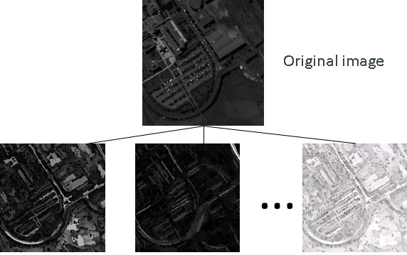
Figure 1: Spatial information modelling
Contact: prof.dr.ir. Hiep Luong
References:
- W. Liao, M. Dalla Mura, J. Chanussot, R. Bellens, W. Philips, "Morphological Attribute Profiles With Partial Reconstruction," IEEE Transactions on Geoscience and Remote Sensing, vol. 54, no. 3, pp. 1738 - 1756, 2016.
Image classification in hyperspectral images
Hyperspectral sensors collect information as a set of images represented by hundreds of spectral bands. While offering much richer spectral information than regular RGB and multispectral images for classification, this large number of spectral bands creates also a challenge for traditional spectral data processing techniques (e.g. Hughes phenomenon). A new framework of semi-supervised feature extraction method was proposed to reduce the dimension of both the original hyperspectral data (Figure 1), and the morphological profiles generated on the features extracted from the very high resolution urban hyperspectral data (Figure 2). Our technique can use limited labeled samples to improve the classification results.
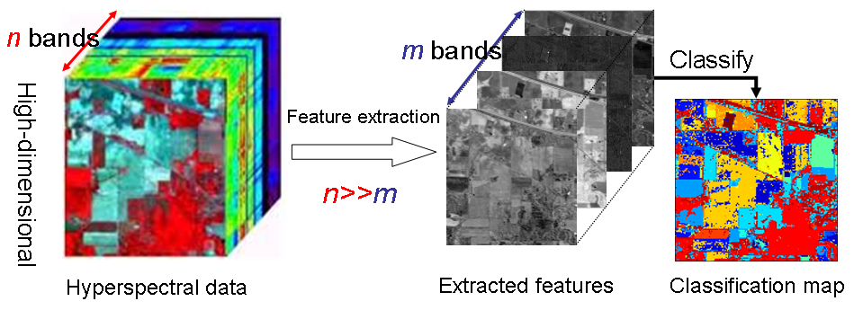 Figure 1: Reduction of original hyperspectral data |
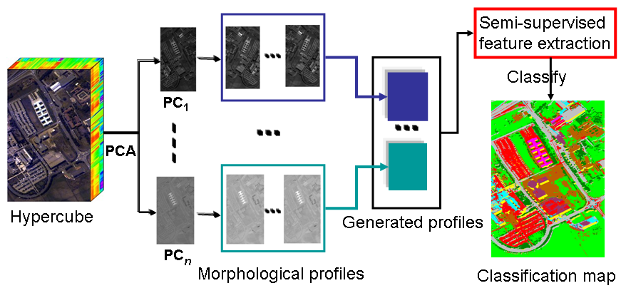 Figure 2: Reduction of morphological profiles generated on the features extracted from original hyperspectral data |
Contact: prof.dr.ir. Hiep Luong
References:
W. Liao, A. Pižurica, W. Philips, Y. Pi, “Feature extraction for hyperspectral images based on semi-supervised local discriminant analysis”, IEEE Joint Urban Remote Sensing Event ‘JURSE 2011', pp. 401-402, 2011.
W. Liao, R. Bellens, A. Pižurica, W. Philips, Y. Pi, “Classification of Hyperspectral Data over Urban Areas Using Directional Morphological Profiles and Semi-supervised Feature Extraction”, IEEE Journal of Selected Topics in Applied Earth Observations and Remote Sensing, accepted.